|
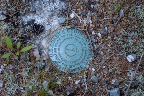
1934 Survey |
|
Survey markers put in
place by the United States Coast and Geodetic Survey agency such as this
one can be found in various locations in this area as well as in most
every state.
|
|
The name of a street here in
Livingston has been mispronounced for many years, and more than likely,
many people really didn’t realize what the correct name really was until
street signs were put up around town. The street I’m referring to is
usually incorrectly pronounced as "Tar Hill" when actually, the right
name is "Tower Hill." Do you have any idea how it got that name? With
some research and the making of a few phone calls, I’ve learned that
somewhere near the very top of Tower Hill Road, the remains of a stone
tower can still be seen today. I don’t know where the exact location is,
and it seems there’s no one alive today who knows why the stone tower
was constructed or what its purpose was. It is believed to go back to
the days when only Indians roamed this area and possibly back even
further. However, there is one tower that was constructed in that same
area as the stone tower is believed to have been located and I have been
able to find out just a little bit about that one. One small paragraph
in the Robert and Mary Eldridge History of Overton County book says
this:
"A party of the U.S. Coast and Geodetic Survey located in Livingston in June 1934 for the purpose of making surveys in Overton County. This project was under the direction of Maurice A. Hecht and composed a company of sixty-five men and a fleet of thirty-two trucks, with nineteen steel towers. A tower seventy-seven feet tall was erected on the South side of the Livingston Academy campus in Livingston (now A.H. Roberts Elementary School), and a sixty-four foot tower was erected on Pilot Knob near Monroe, and one on Tower Hill near Allons, in order to carry out the triangular survey." I researched the internet to find out what I could about the U.S. Coast and Geodetic Survey and learned that it origins go back to President Thomas Jefferson. In 1807, he created the nation’s first physical science agency, and today, some two hundred years later, parts of this early organization are still operating. One of the oldest agencies in our system of government, this agency of the Federal government is one very few people have ever heard of other than those working within that branch of the government. There is a vast amount of information on the internet about this agency, but it is so complex, I found it very difficult to grasp just exactly what all was involved with the work they did when that group of sixty-five men and a fleet of thirty-two trucks loaded with nineteen steel towers did when they rolled into Livingston seventy-three years ago. Part of what they did here and in other parts of our nation involved the surveying of mountains, plains, deserts, and the shores of the United States and its territories and they did so without the aid of all the modern technology we know about today. The United States Coast and Geodetic Survey became legendary for the accuracy and precision of the surveys they completed. One phase of their work helped to determine property lines throughout much of our nation.
|
|
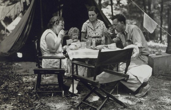
Commander Maurice A. Hecht is shown in this photograph taken somewhere in Tennessee in 1934. Since the Tower Hill project took place in June of 1934, it is possible the picture may have been made there, or possibly on Pilot Knob near Monroe. Others shown in the picture are unidentified.
|
| If the
information in the Eldridge history book is correct, it appears that the
three towers were constructed in this area for the purpose of what was
called a triangular survey. Measurements and distances between these three
towers were figured out and recorded. One website contains over one
hundred and fifty photographs depicting Coast and Geodetic Survey
activities in determining distances, latitude and longitude, and
directions between points by the method of triangulation. All this is
Greek to me. The Eldridge book also indicates this group of men that came to Livingston in 1934 was under the direction of Commander Maurice A. Hecht, a native of Chicago, Illinois. The photograph used with this story was made in Tennessee in 1934, and since that was the year this government agency was working in this area, it may be possible that the picture was made either on Tower Hill or in the Pilot Knob area. Commander Hecht was a hydrographic and geodetic engineer, and worked on various projects, including surveys of the Arctic Coast of Alaska. There is no information to tell us who is in the picture with him. I’m guessing he took his family along as often as he could, otherwise he was probably separated from them for long periods of time. His education includes receiving a degree in civil engineering from the University of Wyoming. He served as instructor in civil engineering at Northwestern and was president of the Northwestern University Engineering Society. I can’t help but think that the constructing of these three towers created a lot of interest with the local people here. I wonder who Commander Hecht made the acquaintance of while this project was going on this area. The job must have taken a good bit of time which provided plenty of opportunities for local people to get to know not only the Commander, but the crew members as well. Did this group just "rough it’ while building these towers? Did they live in tents? Where did they get their drinking water and water to bath? Nothing on the internet was I able to find that told me the answers to questions like this. I would have found that kind of information much more interesting than what I did find. Even an email to the history department of the U.S. Coast and Geodetic Agency didn’t serve any useful purpose with my research for this story. Even today, there are many survey markers that can be found in this area bearing the name U.S. Coast and Geodetic Agency such as the one with this story. James Hunter told me of several nearby locations where this type marker can be found. Just exactly how these markers fit in with the work of this crew is a mystery to me as well. Our son, Michael, has seen one out in Texas not too far from where he lives, but he had no idea what it was. Many unanswered questions come to my mind about this entire expedition, and one is, were the towers dismantled after the survey work was completed? And, did they leave the one at Pilot Knob in place and maybe later, it became a fire tower? I feel sure there are answers to these questions filed away somewhere along with all the information that was put together from the survey work done here in 1934. And I’ll end with one last question, was that road in Livingston given the name "Tower Hill" after Commander Hecht and his crew departed? I suppose it was, but one question I do know the answer to is how the name "Tar Hill" came about. We southerners are responsible for that.
|
|
Follow Up Article:
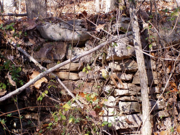
In connection with a story I did earlier about Tower Hill, James Hunter has provided me with some information he has concerning the mysterious stone tower that once stood near the top of the mountain. James describes Tower Hill as an area between Allons and what was formerly known as Halls Cove but is now identified as Hidden Valley. Here is what he shared with me: "When I was a small boy, I heard people speak of Tower Hill in hushed tones. This sparked my curiosity as it sounded mysterious. I started asking questions and got various answers. Someone said it got its name from the early settlers there who were from North Carolina and called "Tar Heels." My grandmother said, ‘No, there used to be a tower there and the hill was named Tower Hill.’ I asked what kind of tower it was. My grandmother said she thought it was a tower used by map makers who climbed the tower so they could see the surrounding country and be able to draw a map of the country. (This tower James’ grandmother referred to is not the same as the stone tower.) I learned further that there was an old abandoned school house or church house there. They said a man by the name of Neeley had been struck and killed by lightning while passing and was laid out in this church prior to his burial. People were afraid to pass by there at night after the death of Mr. Neeley." Additional information that had been passed on to James Hunter by the late Dewey Coffman has this to say about the mysterious stone tower, the remains of which are believed to still be near the top of the mountain. "A stone structure known locally as the stone tower stood on the summit of Tower Mountain three miles northeast of Livingston. This so called tower was found there by the first whites who visited the region. They believed it to be of Indian origin. It gave the name to the mountain. It was constructed of firm sandstone slage broken in good building shape and was nearly square with corners somewhat rounded. It was about eight feet square and eight feet high and was hollow. This tower was partially disassembled around 1870 and used in the constructing of chimneys in the homes of Reese Ogletree, James Burgess, and a Mr. Beard. Some local men dug beneath where the tower stood and found nothing of interest to them. It was said that while they were digging beneath the tower, they heard a doleful or sorrowful sound. There were a lot of grown up people that were afraid to go that way for a long time. This information furnished by J.L. Gunnels, age 60, and Paul Neal, age 70, who lived within sight of the tower when boys. This structure was probably an above ground rock burial chamber. A few somewhat similar structures are reported in Knox County, Tennessee, chimneys, ten or fifteen in number, like stone chimneys, open at the top, located just below the mouth of the French Broad River." The date this information was obtained by Dewey Coffman is unknown. James suggested that the construction of the tower might possibly have taken place during the time of what is known as the Mississippian period, a time that preceded native Americans we are more familiar with. According to information on the internet, the Mississippian culture was a mound building Native American culture that flourished in what is now the Midwestern, Eastern, and Southeastern United States from approximately 800 A.D. to 1500 A.D. The Mississippian peoples were technologically comparable to the European Copper Age, and have been called Master Farmers. They grew and stored corn, beans, squash, pumpkins, sunflowers, and tobacco. They cultivated their agricultural fields with tools of wood, bone, and stone. The harvests were collected in baskets. Animals such as raccoon, turkey, rabbit, beaver, squirrel, turtles, and deer were hunted. Skins were tanned to make clothing and no part of the animal was wasted. Deer may have been hunted in several ways. A lone hunter could camouflage himself with the hide of a deer in order to approach the animals. Fires might have been set in the woods to drive the deer into open areas. The final kill was made with bows and arrows Metals such as copper were cold hammered and worked into various forms of ornamental or ceremonial objects. Smelting was unknown. Clay, fired into pottery, was the only structurally altered raw material. Even so, Mississippian craftsmen achieved remarkable results in knapping, grinding, carving, and weaving natural materials, often expanding on designs and techniques pioneered by earlier cultures. Women constructed pots by coiling and modeling local clays. These vessels were used for storing food and drink. This early Mississippian pottery was made in many sizes and shapes suited to a variety of everyday and ceremonial uses. Decoration was in the form of effigies (images or representations of people or animals).Designs were woven into baskets and fabric. Stone, wood, bone, shell and other materials were probably utilized, though unfortunately, organic material does not survive well in the moist, acidic soil of the Southeast. Based on evidence from other archaeological sites and upon historic accounts of the Indians, people decorated themselves with shell gorgets, beads, tattooing, paint, elaborate hairdos, feathers and many types of ear ornaments. In Rhode Island, a 751 acre property known as the George B. Parker Woodland is owned and maintained by the Audubon Society. Open year round, this impeccable area of woodlands is also famous for its collection of more than 100 mysterious cairns (mounds of stones piled up as a memorial or to mark a boundary or path). These beehive-shaped stone piles range from two to four feet in height and are spread throughout a tract of land surrounding a trail through this property. Many theories surrounding the origins of the rock cairns have surfaced, including theories that they were built by the Narragansett Indians, Celtic settlers, or colonial farmers. Several years ago, Dennie Chilton had seen the stone tower on Tower Hill Road and described it to me as standing several feet tall. What little of it that remains today is probably what was the base of the tower. It’s really too bad that over the years it has been almost totally demolished. More than likely, those who have carried the stones away had no idea the very thing they were tearing down may possibly have been put there by a civilization of people who were the very first to set foot in the area we know today as Tower Hill. Do you suppose any of those doleful, sorrowful sounds might still be heard coming from those ancient stones that ended up in someone’s chimney???
|
|
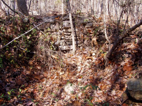
One view of the stones that remain of what is believed to have once been a stone tower.
A message of "Do Not Disturb" seems to be sent by the fallen tree branches that lie across the stones placed there many years ago.
|